Floridians brace for the arrival of Tropical Storm Ian, which is forecast to rapidly intensify on Sunday

[ad_1]
CNN
—
Tropical Storm Ian is forecast to rapidly intensify as it barrels through the Caribbean and the Gulf of Mexico before weakening by the time it reaches Florida later this week, according to the latest update from the National Hurricane Center.
Ian, which developed Friday in the central Caribbean Sea, is forecast to rapidly intensify Sunday, increasing its wind speeds by up to 35 mph over the next 24 hours to become a Category 3 hurricane by late Monday before it reaches western Cuba, the hurricane center said. Meteorologists predict the storm will peak at Category 4 strength over the eastern Gulf of Mexico in three days.
Ian is then expected to reach the US, according to the National Weather Service in Miamibut there remains uncertainty about its forecast track, with models showing a wide spread of possible scenarios after Tuesday: On Sunday morning, the European model showed landfall along Florida’s west-central coast on Wednesday evening, while the American model showed landfall across the Panhandle Friday morning.
The hurricane center’s forecast splits the difference, showing landfall across the Big Bend of Florida on Thursday night as a weakening hurricane.
“Regardless of Ian’s exact track and intensity, there is a risk of dangerous storm surge, hurricane-force winds, and heavy rainfall along the west coast of Florida and the Florida Panhandle by the middle of next week,” the hurricane center said.
Across the state, local officials are urging residents to be prepared in the event of flash flooding and damaging winds.
“This is the calm before the storm,” Naples Mayor Teresa Heitmann told CNN on Saturday. “We experience this kind of adrenaline before a storm and the path could change at any time, but we want our citizens to be ready.”
Ian is approximately 320 miles south-southeast of Grand Cayman and moving west-northwest at 12 mph (19 kph), according to the hurricane center’s update Sunday morning, with maximum sustained winds reaching 50 mph (85 kph).
A hurricane warning is in effect for Grand Cayman, and forecasters are becoming increasingly confident residents in western Cuba will face “life-threatening” storm surge and hurricane-force winds Monday, the hurricane center said. Hurricane and tropical storm watches have been issued for parts of western Cuba.
Tropical storm conditions are possible across Cuba on Monday afternoon, and hurricane conditions will likely follow late Monday into Tuesday. Ian is forecast to bring 4 to 8 inches of rain with isolated totals up to 12 inches possible in western Cuba. Storm surge of 9 to 14 feet is also forecast along the coast of western Cuba in areas of onshore winds Monday night into Tuesday.
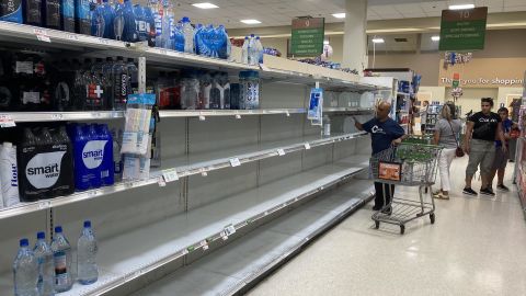
As the storm approaches Florida, authorities are distributing sandbags and asking Floridians to prepare their property to reduce the risk of hurricane damage and to stock up on supplies like radios, water, canned food and medication. Residents should also pack up important documents and know their evacuation routes.
On Saturday, Florida Gov. Ron DeSantis expanded an emergency order to include every county in the state, saying conditions are “projected to constitute a major disaster.” President Joe Biden declared an emergency for Florida and ordered federal assistance to supplement response efforts.
Concerns over Ian’s arrival have also delayed the Artemis I rocket’s third launch attempt planned for Tuesday.
Storm surge – when the force of a hurricane or storm pushes ocean water onto the shore – can be one of the greatest threats to life and property from a hurricane.
This is the primary reason Miami-Dade County residents are asked to evacuate before a hurricane, according to county officials.
“We’re outside of the cone of uncertainty. We can’t relax,” Miami-Dade County Mayor Daniella Levine Cava told CNN on Saturday. “We know there’s always a possibility it will shift. The storm has continued to move westward. This is the time everyone should make sure they have a plan.”
Levine Cava urged residents to make sure they have enough food and water and check their storm surge planning zone.
“We’re very hopeful that even with a major rain event, we’ll be able to manage it,” she said. “We’re on standby. We have extra pumps, and we’ve worked with the South Florida Water Management District to lower canal levels.”
Miami-Dade County is preparing its “extensive shelter system,” including for those fleeing the Florida Keys if evacuations are ordered there.
In Naples, Heitmann said she’s already seeing lines at the gas stations as residents brace for the potential hurricane.
“They’re taking it serious, and I encourage those that are not to always take a storm serious, because you can never estimate where that storm might turn. And we need to be prepared and if it’s not coming directly for us, it might have strong winds,” Heitmann said.
In Sarasota, authorities are checking on generators, planning with local police, trying to estimate how much flooding is possible and warning residents to be prepared, Mayor Erik Arroyo told CNN.
“Don’t underestimate the dangers that come with gusts, with storm surges, with flooding, especially us being a coastal city. So we’re telling them to go now, be prepared early,” Arroyo said.
[ad_2]
Source link